This is the full version of the article. Click here to return to the blog's home page.
Forest Service, Hiking Nonprofits Meet to Discuss Eagle Creek Fire Recovery Effort
Nature and funding largest uncertainties on path to future of trail system
By Chris Carvalho
Entry 20: January 12, 2018
This article was updated January 19, 2018 with new information supplied by the Forest Service.
On December 1, 2017 the Forest Service held a meeting to discuss recovery efforts in the Columbia Gorge in the wake of the Eagle Creek Fire. At the meeting were representatives from the Forest Service including Stan Hinatsu and Dawn Stender. Oregon State Parks sent a representative. Also in attendance were nonprofit representatives Roberta Cobb from the Pacific Crest Trail Association (PCTA), Ryan Ojerio from the Washington Trails Association (WTA), Maegan Jossy from Friends of the Columbia Gorge, and Steve Kruger, Jaime English, and Tom Kloster from Trailkeepers of Oregon (TKO). There was also a prior meeting held in Cascade Locks in October. Together, the group will be called the Gorge Trails Recovery Team.
The focus of discussion was how nonprofits can work with the Forest Service to aid in trail recovery and the role of federal funds in the effort. A follow-up meeting is planned for January 2018. The Forest Service is on track to complete assessments of affected trails by the end of 2017. Trail repair work will wait until spring 2018 at the earliest, until the full impact of winter weather has ended. A number of factors will affect the scheduling of work on each trail: the amount of damage, funding, crew staffing, and accessibility. On January 19, the Forest Service published a summary of the year-end assessment. Detailed reports on the status of each trail are available here.
The Forest Service has released a soil burn severity map from aerial surveys that indicates fifteen percent of the 49,000-acre fire area has been severely burned. About 30 percent of the area is moderately burned, and the remaining 55 percent has very low or unburned impact. Trails near Larch Mountain, Nick Eaton Ridge, Eagle Creek, Tanner Creek, Ruckel Creek, Oneonta, and Horsetail Creek are most severely affected.
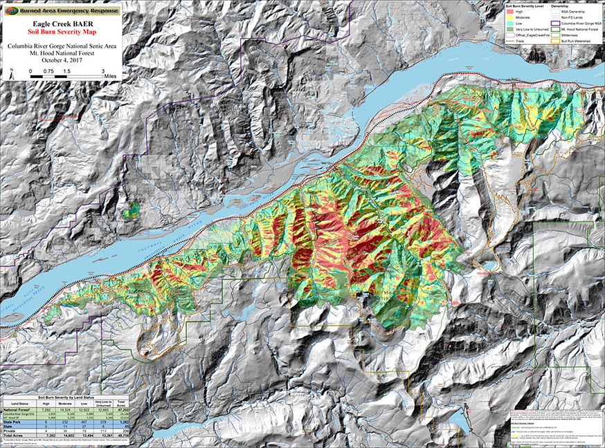
Soil Burn Severity Map (click to open larger
version)
There are 121 miles of trail in the fire area that are closed to the public for safety. Many hazards exist including unstable soil and rocks, fallen trees, burned-out bridges, and landslides. Boulders and talus material in the gorge are held together by a covering of moss. When this burned away, areas that were once stable now have persistent rockfall. The closed trails make up about 60 percent of the total trail mileage in the Scenic Area. Because most of the impacted area is within the Mark O. Hatfield Wilderness, the Forest Service's management policy calls for "little to no human intervention on the forest's natural regeneration process."
There is high interest in the hiking community to learn more about the fire's impact on trails. More photos and reports are needed to keep hikers informed. (Note: Many photos are now available by reading each assessment report.) An education effort could help to discourage hikers from illegally entering the burned area. There have been many instances of people trying to enter closed areas, and the Forest Service has given out over 150 warnings and 49 citations to scofflaws. The interconnected trail system complicates plans to reopen portions of it, as hikers will be tempted to enter dangerous areas through trails that are repaired and safe to hike on.
Commentary: My review of the reports completed so far is that the amount of damage and reconstruction work is sobering. Hopefully the magnitude of work will foster a much-needed change in the public's relationship with the gorge's trails. In the past, we've taken our trails for granted. Going forward, my hope is that there will be a fierce sense of ownership and responsibility toward the region's trails, and changes to policy that will ensure the monumental work to be done won't be wasted or forgotten any time soon.
Friends of the Columbia Gorge is planning to hire a temporary stewardship coordinator as a one-year position to manage volunteers from their organization. They are involved in publicity to direct hikers to alternative trails during the burned-area closure. There is concern that there will be a major increase of visitation on the Washington side of the gorge and the Mt. Hood area in 2018 which could cause problems with congestion, trail damage, and habitat impacts on those trails. Managing this increase will place an additional strain on resources. On the Washington side, the WTA is working on maintenance planning for 2018 and will reserve lower-level projects for the Trail Skills College, an annual spring event that provides training for trail volunteers. WTA will hire a full-time person to be a crew leader and volunteer coordinator, along with a full-time seasonal person to assist with leading work crews. Over 4,000 people have signed up for volunteering to help with fire recovery. One strategy to put this group to work quickly is to have some volunteers work on trails that would experience increased traffic, allowing for training that would also address some of the increased impact outside of the burned area.
There was discussion among the group on a change in direction, moving from a "transactional" relationship with the Forest Service to one that's "transformational." A hopeful sign is the Forest Service beginning work on a new trail plan for the Scenic Area to begin to address the issues of sustainability that have affected the trail system for a long time. The group expressed strong support for completing a plan. To be effective, many stakeholders would need to be involved: the hiking community, ecologists, firefighters, residents, and businesses that serve the recreation community.
Part of the discussion recognized a near-term opportunity to find ways to "do no harm" when reopening facilities to the public. Now that everything is closed, it's possible to reevaluate how things can be done in the future to adopt better approaches to managing impact. That could include some long-term closures for natural restoration at sites such as Oneonta Gorge or Munra Point. This approach carries risk, however. Unless new trails can be built quickly, there will be increased pressure on trails outside the burned area and on the small number of trails that are opened in the early stages of recovery work. There's only one workable solution for that problem: limiting access to other gorge trails through a permit system, parking restrictions, and/or closures on certain days of the week. The sheer volume of work makes it highly unlikely that any new trails could be built fast enough to address the high demand, at least for 2018. The Forest Service said that trail recovery in the gorge could be a "decades-long effort."
Congestion is already happening on some open trails. The video below shows the parking area at Catherine Creek, a popular trail east of the town of Bingen, Washington, on Saturday, January 13.
The Forest Service has assessed 22 miles of twelve trails in the trail system including photos of the damage. TKO is working with the Forest Service to help release some of the information to the hiking community. Because a significant amount of assessment work remains, the Forest Service doesn't expect to have crews working within the burned area by the time of Trail Skills College for 2018. Only a few less-impacted trails will be ready for restoration by that time, such as Herman Creek and Trail 400, the east-west trail at low elevations on the Oregon side of the gorge. To accelerate work, the Forest Service may be able to seek an exemption to allow chainsaws to be used in the wilderness portion of the trail system. A way to improve integration between nonprofits and the Forest Service might be to embed a representative within the Forest Service office in Hood River. If there's one common thread running through what rangers are finding, it's that unknown and changing conditions within the fire area mean there's no certainty of when most trails can reopen. Below are photos of some of the damage along the Horsetail Falls Trail #438:
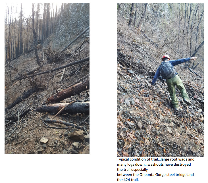
Excerpt from report
of damage to Horsetail Falls Trail #438
Funding is the major question facing rebuilding of the trail system. There are many questions and few answers at the current time. There was discussion on what sources to pursue today: volunteers, crowdfunding, emergency funding sources within the Forest Service, and other sources not yet on the radar such as sponsorships or grants. While there are many ideas, very little is known on what will be available yet. There is approximately one million dollars in an account from unspent Northwest Forest Pass fees, but the entire sum could easily be spent just on a portion of the work needed on the Eagle Creek Trail alone. The Forest Service has asked for additional funding to help with trail repair and to increase capacity, but only a portion of the amount requested has been awarded. Due to issues with the Federal Lands Recreation Enhancement Act, fees the agency charges can only be used at nine designated sites on the Oregon side of the Columbia Gorge where the fees are collected. This restriction prevents fee dollars from being put to work at other parts of the burned area, so a different funding source must be found to repair those trails. Establishing new fees is a lengthy process, and can't be completed in the timeframe needed to do the repair work.
Several working groups were formed to divide up the recovery effort. Steve Kruger will lead volunteer efforts and the near-term response. Jaime English and Ryan Ojerio will work on planning, Roberta Cobb will represent nonprofits in organizing volunteer work crews, and Tom Kloster will work with Rachel Pawlitz of the Forest Service on communications. The next meeting will happen in January 2018.
A note on transparency: The December 1 meeting wasn't announced to the public. When government agencies meet to discuss policy decisions, the Sunshine Act requires that the meeting be announced to the public a week in advance in the Federal Register. More openness about the recovery work is warranted because of the large number of recreationists affected by trail and campground closures, the economic impact on the region from reduced visitation, policy changes that could change the way trails are used in the future, and the fact that volunteers will perform much of the work. I raised this issue with the Forest Service, and was assured that the next meeting will be announced to the public. The explanation of why the earlier meetings in October and December weren't announced was that they only concerned working with nonprofits for planning purposes addressing how to work together, and not decision-making.
Chris Carvalho has a Bachelor of Science degree in chemical engineering from the University of California at Berkeley. He is a photographer and blogger on public policy, environmental, and conservation topics.