

![]()
A web log for enhancing the understanding of human impact on the natural world
| Appreciating Nature's beauty through photography has been a focus of my life since I was a teenager, but the time has come to do more. I am taking my work in a new direction to highlight threats to the natural world. I'll still do fine art photography, but I've come to realize that without doing something concrete to rally public support for protection both my work and the joy we all experience outdoors are likely to perish. My blog Seeing Nature will share insights on current topics. You won't find environmental extremism here; I aim to be thoughtful and critical of unsound thinking on both sides of the discussion on conservation. Please read along, but promise me something: After you're finished, take some action to help the natural world. Then turn off the computer and get outside. The quick link to this blog is http://tinyurl.com/3nau4l6 |
Summary of Posts
Leave No Virtual Trace
April 15, 2018 |
Leave No Virtual Trace: Thanks to social media sharing, mobile phones are now weapons of mass wildland destruction
New ethics needed to address Internet-enabled mobbing of natural areas
Entry 21: April 15, 2018
By Chris Carvalho
Less than a quarter-century ago, recreationists had only paper maps, guidebooks, and word of mouth to discover new places to visit.[1] A few online articles were beginning to appear. Then the Internet snowballed. In 2018 smartphones are almost universal, putting cameras, data access, global positioning, search engines, and instant social media sharing in the hands of nearly every tourist and hiker. This profound change has made it possible to show a sensitive landscape to a multitude of people at the push of a button, complete with driving instructions. The Internet’s viral quality of unlimited replication can multiply one picture to millions of copies and views in a few days. As a result, delicate places have become overrun by selfie-snapping visitors eager to document their trip to a cadre of virtual “followers.” The integration of these technologies into smartphones has weaponized our mobile devices into tools for wildland destruction.
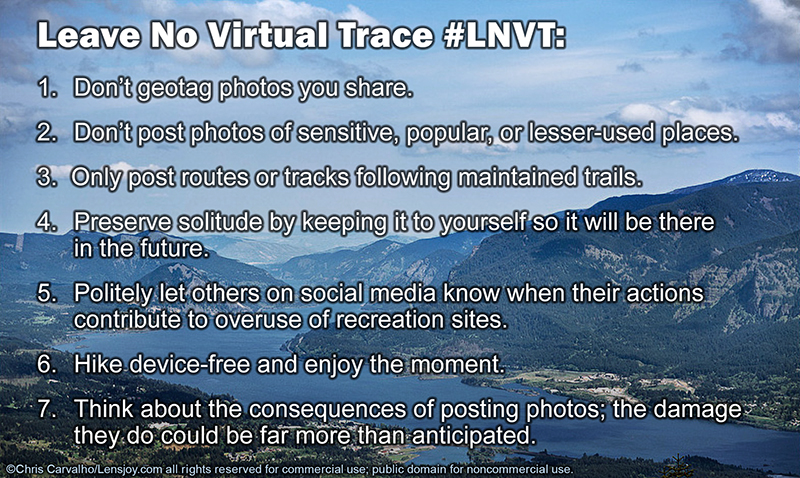
Leave No Virtual Trace Principles
Download
high-res image
Before the arrival of the Internet and smartphones, we had to do real research to find places to enjoy solitude and the beauty of nature. It cost us money and time to do it, and those costs put a brake on visitation impact that kept wildland overuse in check. In today’s world, finding information is fast and free thanks to search engines such as Google, whose original motto of “Don’t be evil” was dropped in 2015.[2] Libraries, bookstores, and hiking clubs used to be where we went to gather hiking trip ideas. Now, they are largely irrelevant.
Readers shouldn’t get the impression of a conspiracy here. What’s happened is that a number of enabling technologies were invented and combined over a relatively short time period. These developments had the unintended consequence of greatly multiplying the number of people who can advertise and promote the beauty of a natural site to a hungry public anxious to find new destinations, and it’s happened at a speed that far exceeds anything we might have imagined.
If we consider the rapid pace of change in only 25 years in the timeline below, the next 25 years could thrust us into a situation where serious damage to wild places may be irreversible. We need to take action now before it’s too late.
What can be done to address the problem?
Hikers now consider mobile phones the Eleventh Essential to summon help
in an emergency. What’s missing is
guidance on limiting the impact from social media sharing.  We need a new addition to the code of outdoor ethics, part of what we
know as the Leave No Trace principles. The
idea of “Leave no Virtual Trace” with the hashtag #LNVT is that new ethic.
We need it because it’s no longer enough to hike, bike, or ride our
stock responsibly and with minimal physical impact.
Even when we clean up after others, we need to take responsibility for
the real-world impact of sharing our experience online, because we can’t be
sure what others might do if they visit a spot based on our social media
posting. Leave No Virtual Trace
means, “Don’t post photos, routes, or coordinates on social media of any place that
would be harmed by increased visitation.” The slogan isn’t my creation; it came from a fellow member of an online
hiking discussion forum who suggested it in a thread I opened on this topic.[3]
I shared this idea with Dana Watts, the executive director of the Leave No Trace Institute for Outdoor Ethics. Her response was measured, believing that no new principles beyond what's currently adopted are needed. Rather, she felt social media sharing can be related to the organization's existing principles of Leave What You Find and Be Considerate of Other Visitors. I don't think this approach is enough to meaningfully create the changes that are needed. I've included her response below in the Appendix.
Other measures that might help include the following:
|
Advance warning by land managers that overused areas will be closed or visitation restricted if social media sharing isn’t curtailed, followed up with action if warnings are ineffective. | |
| Incorporating the Leave No Virtual Trace principle into the ethical code of the Leave No Trace Center for Outdoor Ethics (http://lnt.org/). | |
| Standard signage that’s used worldwide at sensitive sites to advise visitors to curtail posting on social media. | |
| Government and conservation groups could create an open database of areas with excessive impact. Social media companies could check the location of posts against the database and warn the poster of the risks and consequences of sharing, as well as remove geotags from posted photos. | |
| Public education campaigns to make people more aware of how social media sharing can damage habitat, and ask users to go back through their timelines and take down photos of overused areas to reduce future impacts. | |
| An aggressive campaign of charging access fees at overused areas to discourage visitation, with fee dollars devoted to site restoration and construction of new trails to spread out the impact | |
| Social media users can respond constructively when someone’s postings endanger wildlands. | |
| Voters and conservation groups can put pressure on elected officials to restore lost funding for land preservation and recreation development. | |
| Land managers should work with social media companies to enable donations from within applications when sensitive sites are being viewed to create a new funding source for protection and restoration efforts. | |
| Discouraging people from posting GPS tracks of routes that aren't on established trails. Most land managers ban unauthorized trail construction, but a GPS track can do as much damage through the repetitive trampling of multiple visitors following it. |
|
Principles of Leave No Virtual Trace #LNVT: 1. Don’t geotag photos you share. 2. Don’t post photos on social media of any place that would be harmed by increased visitation. 3. Only post routes or tracks following maintained trails. 4. Preserve solitude by keeping it to yourself so it will be there in the future. 5. Politely let others on social media know when their actions contribute to overuse of recreation sites. 6. Hike device-free and enjoy the moment. 7. Think about the consequences of posting photos; the damage they do could be far more than anticipated. 8. Remember that when photos or videos are shared they can multiply views and visitors uncontrollably. Fame is not worth the damage that could result to a fragile area. |
As little as ten years ago, recreation officials were worried that hiking was in decline and would never recover, forcing funding cutbacks and reducing the acreage of protected land. In some ways we can be thankful that the rise of social media has produced the opposite problem: too many users. Unfortunately funding cutbacks did arrive, courtesy of governments that have diverted taxpayer dollars from public lands to other wasteful expenditures.
Social media sharing can be good when it rallies public support to protect threatened habitat. What’s lacking today is a nuanced understanding of when to use it properly and when to turn off the smartphone in the interest of keeping secrets a secret. The lure of online popularity is a calculated enticement that social media companies use to eliminate any discretion on the part of those who post. I’m not optimistic that people will learn to resist that temptation.
While some argue that sharing photos is harmless and it’s irresponsible people who do the damage, it’s important to realize that a considerate hiker who leaves no physical trace yet shares the experience online opens a door to impact from any number of users who might view the post and visit later. Social media sharing makes us feel isolated from the impacts of many who follow our footsteps in the future, but that’s a false perception. Opponents of leaving no virtual trace say no one should control the actions of others because it violates one’s personal freedom and responsibility. Yet, most ethical hikers would never invite a group of strangers along on our trip, expecting no harm will come from it. Even if we don’t see the impact from sharing on the day of our trip, a year later it will be obvious what happened. It’s precisely because we can’t control others’ actions that it’s not wise to post our photos online.
Another argument I’ve heard is that asking people to not post will encourage the opposite as an act of defiance. I’m not convinced. Most of us obey “do not photograph” policies at museums, concerts, and other events. Museums originally said it was to limit fading from flash photography, but most cameras today are so sensitive that flash isn’t used any more. The real purpose of these policies is to get people to pay to attend in person. Asking the same thing of hikers in order to limit impact is a more noble justification and it would likely be quite effective.
We need to consider that there have been many threats to wild areas: motorized travel, logging, litter, livestock, energy development, mining, housing, etc. When each was new it wasn't believed to be a problem but when it reached critical mass, the threat was recognized and required regulation to keep it controlled. The impact of Internet social media is quite possibly another in this long line of threats. It's still early, but the Internet's rapid pace of advancement is forcing us to recognize the problem quickly and respond before it's too late. Hopefully ethics rather than regulation can be the solution, but history says otherwise. Because solitude is a resource worth protecting, we all must learn to Leave No Virtual Trace.
| While You Were Out Hiking |
|
A timeline of developments contributing to social media’s impact on natural areas |
|
August 6, 1991: The first web page was created at http://info.cern.ch/hypertext/WWW/TheProject.html |
|
September 4, 1998: Google was founded |
|
May 2000: Dept. of Defense disables GPS Selective Availability: http://www.gps.gov/systems/gps/modernization/sa/ |
| June 11, 2001: EarthViewer 3D, which will become Google Earth, is released, offering free access to satellite imagery |
| 2002: GoPro, a wearable video camera manufacturer, is founded |
| Feb. 4, 2004: Facebook founded |
| March 2004: Nokia introduces a phone with a 1 megapixel camera, the 7610. |
| February 14, 2005: YouTube founded |
| 2006: GoPro introduces the Digital Hero wearable camera, capable of recording 10 seconds of video |
| March 21, 2006: Twitter founded |
| June 29, 2007: The iPhone was introduced |
| 2009: The US Geological Survey began the release of a new generation of topographic maps online for free download |
| June 12, 2009: Analog TV signals in the USA cease, ushering in high-definition digital video. |
| September 21, 2009: Gaia GPS is introduced, turning a smartphone into a GPS and geotagged camera with instant publishing of routes, for free. |
| 2010: The Parrot AR Drone, a smartphone-controlled quadcopter for consumers, is introduced at the Consumer Electronics Show in Las Vegas. |
| October 6, 2010: Instagram founded |
| October 31, 2011: Global population reaches 7 billion |
| March 21, 2012: Twitter celebrates its sixth birthday, with 140 million users and 340 million tweets per day |
| 2013: GoPro sales reach $1 billion |
| December 2014: 98% of the US population is covered by 4G networks: https://www.gsmaintelligence.com/research/2014/12/mobile-broadband-reach-expanding-globally/453/ |
| August 27, 2015: Facebook reaches 1 billion users in a single day |
| April 26, 2017: Instagram reaches 700 million active users, doubling in two years. |
Appendix: Dana Watts' response:
December 12, 2017
Hello Chris-
This topic has been front and center lately for many people, including Leave No Trace. My colleague Ben Lawhon responded recently to a similar request for the creation of an 8th principle that would directly address social media. This response accurately captures The Center's position on the issue and I hope is helpful:
Thank you for your support of Leave No Trace, and for your email regarding the use, and potential consequences, of social media. This is an issue that we have been hearing more and more about over the past year, and it’s something that we’re actively working to address.
There is little question that social media plays a role in promotion of various outdoor locations, and in some cases, has led to significant biophysical and social impacts. It’s logical to ask, “Would this place be as impacted as it is now had it not been for Instagram, Facebook, Twitter, or Pintrest?”[sic] Social media, like any tool or technology, can be a force for good or it can have the opposite effect. What if every social media post also included a message of stewardship? Think how different things would or could be if this were the case.
As technologies have evolved over the past 15 years we have explored the potential impact to the outdoors, and in some cases, have addressed such issues with Leave No Trace. For example, in the early 2000s when handheld GPS units were made more accurate, more reasonably priced, and smaller, there was justifiable concern about how these devices, and associated activities such as geocaching, could potentially impact the outdoors. Another example dates back to 2013 when drones began appearing on (or above) public lands. Drones are relatively inexpensive and easy to fly. As such, there were genuine and valid concerns about the use of such devices on public lands, which can impact solitude and wildlife, and present privacy and safety concerns. A final example from just a few weeks ago involves the use of personal locator beacons such as the SPOT or the ARC ResQLink, which can be life-saving devices or lead to costly, impactful, and unnecessary rescue operations where the user has simply run out of beer. In each case, we have been asked to provide specific Leave No Trace guidance by adding additional Principles. In some cases, we have provided guidance (geocaching/GPS use) under the existing Principles and in others we’re still working on the most appropriate strategy for addressing issues arising from such rapidly evolving technology.
Because the current incarnation of the 7 Leave No Trace Principles have been in place for nearly 20 years, we don’t take discussions of significant changes lightly. Such discussions are imperative at times but also need to be strategic, thoughtful, and measured. In the case of addressing appropriate use of social media, we feel that it is possible and necessary to tailor existing Leave No Trace information for this purpose rather than creating a new Principle out of whole cloth. There are two current Leave No Trace Principles under which social media can be addressed: Leave What You Find and Be Considerate of Other Visitors. For each Principle, the message about social media will encourage outdoor enthusiasts to stop and think about their actions and the potential consequences of posting pictures, GPS data, detailed maps, etc. to social media. Furthermore, we urge people to think about both the protection and sustainability of the resource and the visitors who come after them. We generally refrain from explicitly telling people what to do in the outdoors, especially in the context of more ethical issues such as the use of social media. The primary reason for this is that Leave No Trace isn't black or white, right or wrong. It's a framework for making good decisions about enjoying the outdoors responsibly, regardless of how one chooses to do so. That said, if we can simply encourage folks to stop and think about the potential impacts and associated consequences of a particular action, we can go a long way towards ensuring protection of our shared recreational resources.
As we have thought through this issue we’re left wondering what the future will bring in terms of technology, communication, and outdoor recreation. Will posting pictures to social media be a thing of the past in five years? None of us know. However, we do know that it is currently contributing to some level of impact in the out-of-doors, which is something we are actively addressing. Not only will we encourage responsible use of social media but we will also embolden and inspire social media users to promote and provide a message of Leave No Trace stewardship with any and all relevant post about the outdoors. Social media, if used the right way, is a powerful tool that can motivate a nation of outdoor advocates to enthusiastically and collectively take care of the places they cherish.
Please know that we are actively working to address the intersection of social media and the outdoors through the appropriate channels. As such, we welcome further input, discussion, and constructive feedback.
Again, we appreciate your sincere commitment to Leave No Trace. It is individuals like you who are making a real difference for our shared lands.
Best,
Dana Watts
Read more from the Leave No Trace Institute on this topic at their blog.
References:
[1] Manjoo, Farhad. “Jurassic Web: The Internet of 1996 is almost unrecognizable compared with what we have today.” http://www.slate.com/articles/technology/technology/2009/02/jurassic_web.html
[2] Basu, Tanya. “New Google Parent Company Drops ‘Don’t Be Evil’ Motto” Time. http://time.com/4060575/alphabet-google-dont-be-evil/
[3] Carvalho, Chris. “The Quiet Pledge: What to do about overcrowding.” http://www.oregonhikers.org/forum/viewtopic.php?f=7&t=24810
Further Reading:
Knepper, Brent. "Instagram is Loving Nature to Death." The Outline. https://theoutline.com/post/2450/instagram-is-loving-nature-to-death. November 7, 2017
Solomon, Christopher. "Is Instagram Ruining the Great Outdoors?" Outside. https://www.outsideonline.com/2160416/instagram-ruining-great-outdoors
McHugh, Molly. "Loved to Death: How Instagram Is Destroying Our Natural Wonders." The Ringer. November 3, 2016. https://www.theringer.com/2016/11/3/16042448/instagram-geotagging-ruining-parks-f65b529d5e28#.evqrskkyg
Chris Carvalho has a Bachelor of Science degree in chemical engineering from the University of California at Berkeley. He is a photographer and blogger on public policy, environmental, and conservation topics.
Forest Service, Hiking Nonprofits Meet to Discuss Eagle Creek Fire Recovery Effort
Nature and funding largest uncertainties on path to future of trail system
By Chris Carvalho
Entry 20: January 12, 2018
This article was updated January 19, 2018 with new information supplied by the Forest Service.
On December 1, 2017 the Forest Service held a meeting to discuss recovery efforts in the Columbia Gorge in the wake of the Eagle Creek Fire. At the meeting were representatives from the Forest Service including Stan Hinatsu and Dawn Stender. Oregon State Parks sent a representative. Also in attendance were nonprofit representatives Roberta Cobb from the Pacific Crest Trail Association (PCTA), Ryan Ojerio from the Washington Trails Association (WTA), Maegan Jossy from Friends of the Columbia Gorge, and Steve Kruger, Jaime English, and Tom Kloster from Trailkeepers of Oregon (TKO). There was also a prior meeting held in Cascade Locks in October. Together, the group will be called the Gorge Trails Recovery Team.
The focus of discussion was how nonprofits can work with the Forest Service to aid in trail recovery and the role of federal funds in the effort. A follow-up meeting is planned for January 2018. The Forest Service is on track to complete assessments of affected trails by the end of 2017. Trail repair work will wait until spring 2018 at the earliest, until the full impact of winter weather has ended. Click here to read more.
Wake Up And Smell the Smoke
The 2017 Eagle Creek Fire teaches lessons in fire policy and involving the public in crafting it.
Entry 19: October 19, 2017
This article was updated October 22, 2017 with additional
information.
|
|
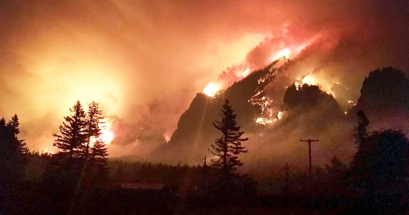
In the classical Greek legend of Pandora's Box, Zeus was angry with Prometheus for giving people fire. He sent a beautiful woman, Pandora, down to earth with a box, saying it must never be opened. She married Prometheus' brother. Curiosity eventually overcame Pandora and she opened the box, unleashing troubles of every kind on humans. It was the gift of fire that started it all. Click here to read more...
Everyone's a Winner: The 2017 Solar Eclipse
Photographing the Great American Eclipse of 2017 from Central Oregon
Entry 18: September 9, 2017
 |
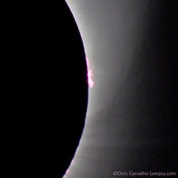 |
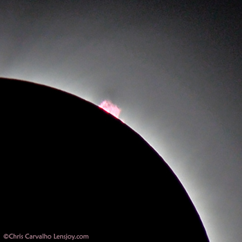
Depending on who you talked to, the 2017 solar eclipse ranged from a spiritual experience to the media event of the century, or possibly Armageddon. What you wanted to see in it, you found, much like a Rorschach test given to millions of people at the same time. For me, it was the chance of a lifetime and not to be missed. We made reservations a year in advance for a motel in Redmond, Oregon so we could be within the path of totality as Portland is just outside it. Already rooms were getting hard to find. By June we heard all kinds of dire predictions of fuel shortages, traffic jams, food stores and restaurants selling out, cell phone outages, and power failures. Newspapers said that over one million tourists would visit Oregon for the event, causing unprecedented strain on communities fortunate enough to be in the darkest part of the moon's shadow for one or two brief minutes. Click here to read more...
Forest Service Hoards $14 Million from Recreation Fees; Trails Suffer
An Embarrassment of Riches, Poverty of Programs
Entry 17: October 2, 2016.
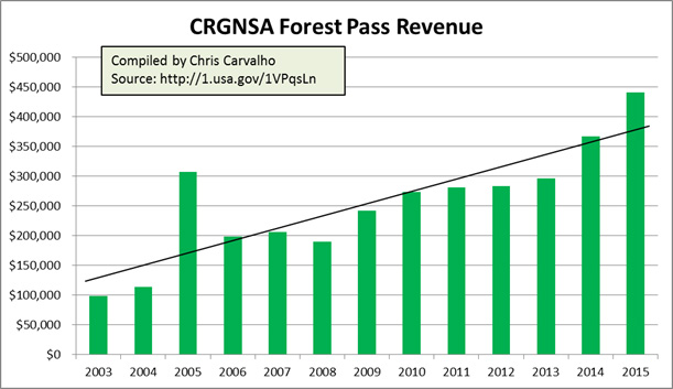
Hikers in the Columbia River Gorge National Scenic Area (CRGNSA) are familiar with the Northwest Forest Pass, a $30 annual permit required at many sites on federal land. The fee program operates in Washington and Oregon, with collections allocated to participating regional forests. Revenues in the Scenic Area have climbed steadily from $100,000 in 2003 to $441,000 in 2015, a 7% annual growth trend. Click here or on the chart below to read more...
An Open Letter to Governor Jay Inslee
Serious flaws in Vancouver oil-by-rail terminal risk analysis create false impression of safety
Entry 16: June 16, 2016.
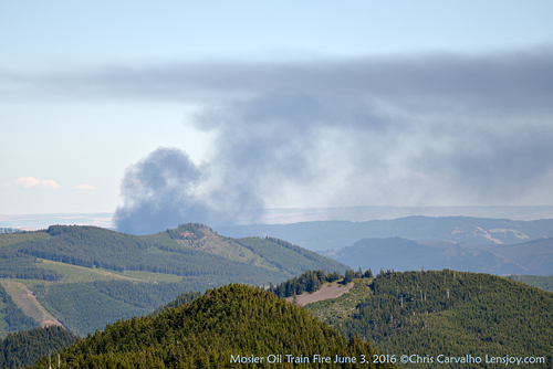
The recent derailment and fire of a train carrying crude oil in Mosier, Oregon led me to question the reasoning in the draft environmental impact statement for the Vancouver Energy oil terminal and conduct an independent review. What I found was a number of flaws, errors, and omissions in the risk analysis. If the terminal is built, we can expect to see an oil release event in the Columbia Gorge once every 18 months according to industry data. The letter below to Washington Governor Jay Inslee explains what I found. Click here to read more...
A Map Salem Doesn't Want You to See
Is Portland the reason Sherman County has one of the highest cancer rates in the nation?
Entry 15: February 14, 2016. 
Sometimes a map is great for improving one's perspective. Residents of Portland, Oregon are upset about recently discovered high levels of arsenic and cadmium at several hotspots in the city, some located near artisan glass manufacturers using the toxic metals to color their glass. As a cancer survivor, I too am angry at the Oregon Department of Environmental Quality (DEQ) for its pro-business attitude that values corporate profits far above human health, even though corporations don't get cancer.
While I care deeply about the situation and want the DEQ to serve the public's interest first and businesses' second, I found something startling that puts Portland's problem into a wider perspective. My natural suspicion was that cancer rates in Portland would be the highest in the state, owing to the greater concentration of industry, automobiles, and their pollution. I was wrong. Here is a map of cancer incidence (all types and all races) in Oregon showing how cancer rates vary by county.
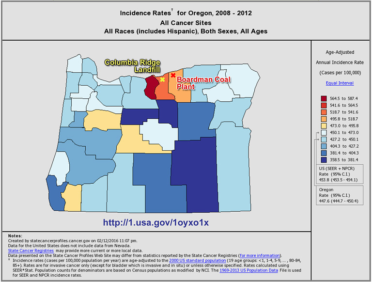
Figure 1. Oregon cancer rates by county, showing
Boardman coal-fired power plant and Arlington landfill sites
The map comes from the National Cancer Institute website and one can easily generate a map for any state and most cancer types, categorized by race and sex if desired. The tri-county Portland metro area (Washington, Clackamas, and Multnomah counties) has an average annual incidence rate of 445 cases per 100,000 population. That's slightly below the national average of 454. The average rate for Sherman (dark red), Gilliam, and Morrow counties (from left to right above, with Portland General Electric's Boardman coal plant in Morrow County and Arlington's Columbia Ridge Landfill in Gilliam, serving Portland) is 540 cases per 100,000. That's 21 percent higher than Portland. Sherman County's rate of 587 is an atrocious 32% higher and ranks as the 14th highest of 2,919 US counties with reported data.
While the outrage in Portland over arsenic and cadmium is certainly justifiable, there should be even greater outrage about the situation in Morrow, Gilliam, and Sherman counties. The coal plant (slated for closure in 2020) and landfill deserve careful scrutiny to find out if they are causing these high cancer rates. While the lack of regulation of arsenic and cadmium is troubling, our state authorities need to devote even more attention to understanding and doing something about cancer rates in the rural counties east of us, especially if Portland is exporting its cancer risk there along with its solid waste and coal-fired power emissions. Note: It may not be only Oregon's problem. The Roosevelt Landfill, of similar size, is located in Washington just across the Columbia from Arlington. It handles waste from all over Washington.
The evidence that Portland could be the reason for these rates is admittedly circumstantial. But the high rates in these rural counties are not. I have sent a letter to Oregon's state epidemiologist asking whether this merits concern and will post an update on her response.
Every time we in Portland throw out the trash, turn on a light, or charge our iPhones, we should thank the residents of the counties downwind from Boardman. If they are giving their lives for us to have our electricity and garbage service, will we do anything for them in return?
Chris Carvalho has a Bachelor of Science degree in chemical engineering from the University of California at Berkeley. He is a photographer and blogger on public policy, environmental, and conservation topics.
Eat Organic, or Die
Mounting evidence suggests glyphosate in food supply linked to serious diseases
Entry 14: January 18, 2016.

Roundup®: Not just for weeds anymore; it’s in our breakfast, lunch, and dinner.
I’ve always trusted our foods to be safe to eat. In the summer of 2015, that changed. After some meals I felt miserable, with intense pain in the small intestine. I feared I might be experiencing a return of the cancer I’d been treated for in 2011. That turned out to be wrong, thankfully. After further research and experimentation with my diet, I’ve concluded the pain is from emerging contaminants in the food supply that the US Food and Drug Administration (FDA) should be monitoring and regulating. The contaminants are glyphosate and surfactant additives, used in Monsanto’s herbicide Roundup® and similar products from other manufacturers. Click here to read more...
Heat Wave Cooks Washington's Monarchs
Record heat decimates fall migrating population
Entry 13: August 19, 2015.
In mid-August, a group of volunteers (including myself) planned to work with Professor David James of Washington State University to tag monarch butterflies at a site near the town of Vantage and monitor their fall migration. The work was cancelled due to poor emergence of the fall migrating population of butterflies. According to Dr. James, only about three potential migrant monarchs per hour were observed around August 17th and 18th. It's a devastating count compared to the same time in 2014, when around 22 per hour were observed.
It's the first year since he's been monitoring the site that the population has declined in August. He believes this is due to a heat wave that happened at the same time that the first generation of butterflies was due to emerge as adults at the site in late June and early July.
A WSU climate recording station 2 miles from the Vantage site recorded an average maximum temperature from June 26-July 10 of 103.1ºF. Every day during this period exceeded 100ºF with a maximum of 109º on June 28.
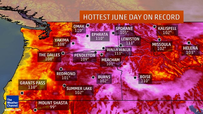
Map from The
Weather Channel showing the hottest temperatures ever recorded in the month
of June
According to Dr. James, "These temperatures exceed optimal temperatures for Monarchs by a significant margin and appear to have had a detrimental effect on population development and survival."
Monarchs face many threats to their future as a species: habitat loss, loss of milkweed from rapidly expanding herbicide use on farms, deforestation at their overwintering sites in Mexico, and now it appears that climate change may pose yet another threat.
I will follow this story and write more as additional information becomes available.
Oregon's Liquid Gold
Bottled water is big business in Oregon, and the public is the loser
Entry 12: April 23, 2015
It rains a lot in Oregon. So it seemed that the Nestlé proposal to bottle a little bit of spring water in the Columbia Gorge wasn't a big deal. It's only half a cubic foot per second, and one tenth of the total volume coming from Oxbow Springs. It creates 50 jobs and property taxes for the struggling town of Cascade Locks. What could possibly be wrong with that? Click here to read more...
Anatomy of a Clearcut
Entry 11: February 8, 2015
SDS Lumber is a timber company operating out of the town of Bingen, Washington. At the end of 2011, it logged 110 acres of land above the Historic Columbia River Highway State Trail in Mosier. The site consists of two parcels, about one third owned by SDS and the remaining two thirds owned by the Warm Springs Tribe. Trees on the site were burned in the 2009 Microwave fire, and a clearcut operation was conducted to salvage the burned timber.
The resulting deforested area was an eyesore that appeared seemingly overnight and angered residents, who had no idea it was happening. The site was on land in the Columbia Gorge Scenic Area designated as General Management Area (GMA) Open Space, where timber harvest was thought to be prohibited. The logged area was visible from towns, trails, and the major highways in both Oregon and Washington. The historic highway trail's character was seriously impacted (Figure 1). Click here or on the photo below to read more and take a virtual tour of the clearcut up close...
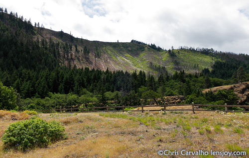
Figure 1. View of clearcut from Mosier Tunnels
Trail (click for virtual tour)
U-Develop Closes: The Decline of Photographic Printing and Why Paper Prints Matter
Entry 10: January 11, 2015

The end of an era; Digicraft closes its
doors.
Sadly, the preferred lab I've used for printing since 2000, Udevelop/Digicraft in Portland, Oregon closed its doors on December 23, 2014. I've worked with them over those years and together we navigated the transition from traditional darkroom enlargements to digital optical printing on photographic paper. But the handwriting has been on the wall for several years now that there is a shakeout of fine-art print shops in progress. They weren't the first lab to close, nor will they be the last. But the world lost a great resource for making and seeing the beauty of art photography. Click here to read more.
This Picture Is Illegal
Proposed regulations to require Special Use Permits for commercial filming/photography
Entry 9: September 26, 2014
If you drive a car, I'll tax the street
If you try to sit, I'll tax your seat
If you get too cold, I'll tax the heat
If you take a walk, I'll tax your feet
The Beatles, "Taxman"
Yes, this picture is illegal. It was taken while US Forest Service interim directive 2709.11-2013.1 was in effect and is (gasp!) For Sale. I was unaware I needed a Special Use Permit just to carry a camera into a wilderness area, take the photo, and show it to you so you could appreciate the beauty of wilderness free of charge, and if inspired, buy a copy to hang on your wall. The Forest Service is taking comments on this policy, so I wrote the letter below. Please add your voice and support free access for photography. Without a backlash from the public, we'll all suffer a great loss as our government erects another barrier to appreciating nature. Click here to read more.
Open Letter to Mt. Hood National Forest
Improved bridge needed to stop hiker deaths
Entry 8: August 22, 2014
Jen Wade
Recreation Manager
Mt. Hood National Forest Headquarters
16400 Champion Way
Sandy, Oregon 97055
Dear Ms. Wade:
I'm going to take some heat from the Forest Service for not sharing this letter privately. However, I've watched this situation evolve since I moved to Oregon in 1981 and hiked to Ramona Falls at least once a year, and I'm fed up. Public pressure is the only way to change it. On August 12, 2014 Brent A. Ludwig, a 34-year-old man visiting from New Lenox, Illinois, was crossing the Sandy River on the Ramona Falls trail during a severe thunderstorm that poured around an inch and a half of rain in less than an hour on the slopes of Mt. Hood above the trail's bridge, where he was crossing with a group of 19 others. A flash flood washed away the bridge, and he was carried to his death as his wife looked on. The day of Ludwig's death I was planning a hike on Mt. Hood, but canceled it when I checked weather radar and saw severe thunderstorm warnings on the mountain.
This isn't the first time. In August 2004 Sarah Bishop, who was a skilled hiker, died under similar conditions in another rainstorm. Click here to read more.
The Eighth Wedge
Entry 7: November 7, 2012
If you have read Al Gore's book "An Inconvenient Truth," Page 280 has a chart of seven wedges representing different approaches to controlling carbon emissions contributing to climate change. The chart is based on a paper by Robert H. Socolow and Stephen W. Pacala published in the journal Science. The paper proposed seven strategies to level off emissions: energy efficiency, renewables, clean coal, forests, soils (stop deforestation and agricultural tilling), fuel switch (coal to gas, oil to heat pump, etc.), and nuclear power.
Source: Pacala, S., and R. Socolow. "Stabilization Wedges: Solving the Climate Problem for the Next 50 Years with Current Technologies." Science 305 (August 13, 2004):968-972.
The premise of the paper is that there is a way to control carbon emissions through these techniques that could successfully mitigate human impact on climate. However, even though the paper talks about current technologies, there are many uncertainties in the success of these strategies. Clean coal, for instance, could be too costly to implement and it relies on unproven technology such as carbon capture and storage. But what if we were overlooking an eighth wedge, a strategy that doesn't require any new technology at all?
Click here to read more on this article
Roadside Trash: Causes and Solutions
Entry 6: March 29, 2012 (updated October 23, 2012)
For several years I've picked up trash along different stretches of roadway. I do it to make the world a better place and as a way to do exercise that produces a benefit to society rather than just to burn calories. Trash pickup is an endless job though; it's hard sometimes to realize that there's no way to make permanent progress.
While doing all that work I have plenty of time to think and I've come up with some ideas that might make a dent in roadside litter. It started with analyzing what gets thrown away. Much of the trash comes from products involved with addiction, such as beer cans, liquor bottles, and cigarette boxes and butts. A lesser amount is fast-food packaging and cups, followed by food packaging from the grocery, and finally random non-food items. Below is what I found on a recent cleanup trip along Old Highway 8 near Lyle, Washington. This road is near a lake, so there's a disproportionate amount of fishing items such as bait cups. Other than that, it's fairly typical. Contrary to what most think, I've never found drugs or syringes over the several years I've done this work. We hear about it on the news a lot, but most trash is quite boring.
| Typical roadside trash (click to enlarge) | 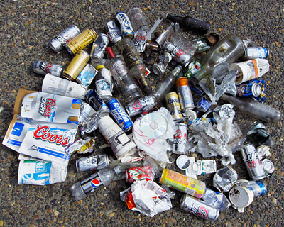 |
Just like on TV commercials, I tried to turn most items so their corporate logos are visible. Click here to read more.
Washington Parks' Discover Pass: The $10 Picnic
Entry 5: March 8, 2012
"They took all the trees, put 'em in a tree museum / And they charged the people a dollar and a half just to see 'em." -Joni Mitchell, "Big Yellow Taxi"
On March 7, 2012 I visited Beacon Rock State Park in Washington to hike the Hamilton Mountain trail. I knew there was a new user fee for visitors because Washington is facing a budget shortfall and wanted park users to pay up. What shocked me was the $10 fee for one day's use at Washington parks. This is called the "Discover Pass." What it looks like to me is that Washington is doing everything it can to discourage people from using their state parks, especially if the visitors aren't wealthy. Perhaps a better name for this fee is the "Discourage Pass." Click here to read more.
Wind Turbines Blow Away Gorge Views
Entry 4: July 2, 2011 (updated January 11, 2013)
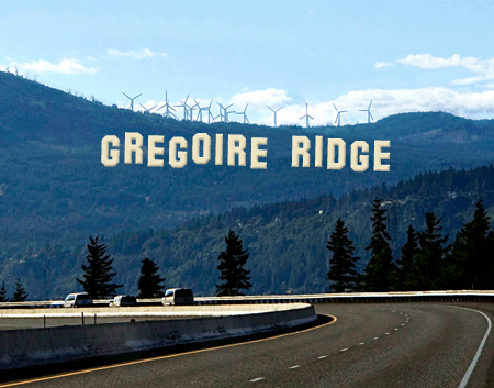
March 5, 2011 update: Governor Gregoire has approved the Whistling Ridge project. Unfortunately, she will be remembered as the governor who trashed the Gorge by allowing wind power development just outside its boundary, opening more land to this kind of destruction. Donate to Friends of the Columbia Gorge if you are in favor of challenging the decision in the courts.
In view of the monumental damage this decision will cause to the region's scenery by opening up wind power development to all comers, I think it's time to rename Whistling Ridge to Gregoire Ridge:
|
|
Image credits: Photo by Karen Chandler Simulation of turbines by GeoDataScape, Inc. Note: This is a simulated image, not a real one. The turbines shown have been approved but not built yet. |
Making Conservation Dollars Work:
Why I left The Sierra Club after 28 years
Entry 3: January 14, 2011
In my last posting I said I'd be writing about some major changes in my conservation giving. Recently I sent a letter to the president of the Sierra Club informing him that I am ending 28 years of contributions to his organization. The text of the letter is reproduced below. It stands on its own to explain my reasons for leaving, but I also want to briefly summarize my thinking. I also sent another letter to a local mountaineering organization resigning my membership for similar reasons.
When I take hard-earned money and give it to a conservation group, I'm doing it for several reasons. I want to multiply my voice by acting in concert with others who share my views. I'm trusting the group to do good things with my funds. I value the group's expertise in making good decisions and prioritizing how much effort is spent on each one. Finally, I expect their efforts to have some tangible benefit in my own life and the enjoyment of nature I value so highly. What I hope is that everyone reading this thinks carefully about what their reasons are for donating, and holds organizations accountable for acting responsibly with their money.
In the Sierra Club's case, in 2008 the organization had $87 million in income according to the BBB's Wise Giving Report. When I look at how much money the Sierra Club is spending on its programs and the lack of scientific, fact-based reasoning behind their initiatives, I now realize that it's an incredible waste of the public's conservation dollars. The club has become so politically charged in their communications that it's no longer an environmental group, it's a political one. Much more good could be done if the money were spent more efficiently and in results-oriented ways.
After I wrote my letter, I found that the club wrote an article saying that Australia "appears to be reaping the climate chaos it has sown" in response to recent flooding in Queensland and drought across the country. Irresponsible statements such as this are not the way I want my money being spent, especially when so many have died in this catastrophe. While Australia bears some responsibility for climate change, any blame for the disaster has to lie proportionately with those doing the most polluting, and that would be China (#1) and the USA (#2); Australia ranks 16th in the global tally of carbon emissions. Clear thinking is a requirement for any organization deserving my contribution. We all need to work together to tackle climate change, and the Sierra Club is fond of pointing fingers rather than encouraging cooperation.
The money that went to those organizations is now going to Friends of the Columbia Gorge, Amphibian Ark, and the Royal Forest and Bird Protection Society of New Zealand.
Before joining any organization, check out its record with the BBB or Charity Navigator. Look at their website and publications and be certain your money will work hard for the environment. Reevaluate how they are doing every year, and don't be afraid to speak out when they're not meeting your requirements.
Update: As of April 5, 2011 Mr. Brune has not responded to my letter. I don't expect he will.
Now for my letter:
Michael Brune
The Sierra Club
85 Second Street, 2nd Floor
San Francisco, CA 94105
Dear Director Brune:
I'm 51 and have belonged to the Sierra Club since I was 22. Over that time I've given thousands of dollars to the club. This year, I'm ending my membership. It wasn't an easy decision, but I felt that given the amount I've contributed and the time I've been a member you deserved to hear about the reasons I've grown disappointed enough with the club's direction to leave it.
It would be wrong to look at my decision as rooted in the adage that people grow more conservative as they age. If anything, I have become more of an environmentalist as I've grown older. What has changed about me is that I've become a lot savvier about how to advocate for change, and the club hasn't kept pace, despite being a much older organization than I am. I'm going to take my money and put it where it can do the most good for the environment, and that's not with the Sierra Club.
When I joined the club, I did it to add my voice to a larger one advocating for protection of the wilderness and a healthy environment, much as John Muir wrote. What I found happened in the intervening years is that the club has taken my money and devoted much of it to things that have little or no bearing on those core principles. It makes sweeping statements that have no basis in fact as if they are Gospel. The club's website proudly claims that John Muir appears on the back of the California quarter. How can that possibly mean anything tangible about the club's integrity or effectiveness in modern times? It's not an award from impartial judges, and Muir isn't alive to comment.
I've watched as the club has grown much larger and its staff have become incestuous, taking on a purpose of their own that feeds on their own thinking, rather than listening to member concerns and ensuring that larger goals align with those concerns while staying true to core principles. Organizations can multiply the power of their members, but at other times they give into the temptation to create new initiatives that members didn't want or need. As an example, the Sierra Club sent me an email today about how to choose toothpaste with the smallest carbon footprint. What a waste of my membership dollars that was. My choice of toothpaste isn't your business; it's between my dentist and me. Fire the staffer who's writing about green toothpaste choices and use the person's salary to hire a conservation lobbyist or do television advertising; that's what the Sierra Club should be doing for its members.
Branching out into areas that aren't key to the club's core principles reduces the power you can wield through staying focused and putting more dollars to work where they can do the most good. Every dollar you receive should go to influencing the public or government officials, or to programs that actually clean up the environment or preserve natural areas. There is a huge expense going toward sending information back to members that we really don't care about. I want my dollars directed toward changing government policy and educating the public who thinks we are a bunch of granola-heads, not going to messages to membership on how to be green to the point where one can't live a moment without guilt about our choices. Your goals will be achieved only when the public sees that the club is looking out for their welfare and therefore responds with support. Today, the club is making enemies from people who could be your best supporters.
Let me give you an example of an outstanding organization I belong to that has its priorities straight and is making a real difference. It's the Royal Forest and Bird Protection Society of New Zealand (http://www.forestandbird.org.nz/). I found out about it on a trip I took to New Zealand a few years ago, and joined immediately. They have a tough job, but they are amazingly effective in protecting biodiversity, gaining public support, and implementing programs that make a difference on the ground rather than waste dollars to fuel useless political infighting. This year I took the money I was going to send to the Sierra Club and sent it to them. Some great domestic organizations are The Nature Conservancy, Friends of the Columbia Gorge, Beyond Pesticides, and Amphibian Ark. They also deserve my money because it goes to work with an efficiency that the Sierra Club can only dream about.
Another big concern of mine is the club's lack of attention to complexity when it communicates to the public and decision makers about environmental issues. Two major initiatives come to mind that illustrate this problem. One is the "Beyond Oil" campaign. The second one is the club's emphasis on wind power as a green power solution. On both of these topics the club has fallen into the trap of becoming a polar opposite of the conservative community, and articulating a solution that grates on the public as being environmentally extreme.
What I expect to see from the club in response to disasters such as the BP oil spill is a program of practical, realistic ideas to reduce our dependence on oil, not the idea that we can totally eliminate its use. There is no way we can do that any time soon given the number of automobiles, buses, and trucks in service worldwide. We won't move this concept from a dream to reality without solving many technical and political problems. Americans simply won't accept the sacrifices that would come with eliminating petroleum use in 20 years. That's a given. What the public needs to see from the club is ideas that will reduce oil use without creating excessive inconvenience for the public or business, along with increased funding for research into the most important advances we need to get there, including biofuels and large-scale energy storage to smooth out the intermittent power from wind and solar energy.
Automobile use can be made much more efficient by batching up small errands into a larger trip, and by installing equipment that monitors traffic on roads and links to navigation systems in cars to show the fastest route to a destination that's updated in real time. That use of technology isn't even on the radar in the club's thinking. People need to drive; what the club can do is show them ways to do it smartly so we accomplish what we need and gain something useful such as more time by being more efficient, instead of the philosophy that the only way to reduce oil use is to make driving inconvenient, more expensive, and hit people in the pocketbook (not a great way to curry favor with the public.) A traffic-monitoring network would create jobs nationwide as well as provide great benefits for everyone in terms of saving valuable time.
The club pushes bicycling as a significant way to reduce energy use but again the idea lacks practicality. Biking sounds great until you're seriously injured from an accident. It's not wise to bike in bad weather or at night, and bikes don't work well for people who must travel long distances, take along the family, or need to haul large items. Try asking someone who lives in rural Kansas to take a bike to Home Depot to buy lumber. When the club's ideas draw laughter from anyone with common sense, you know they are in need of revision. Cycling has a high priority in the club because many of the staff are young people living the myth of immortality who haven't had enough time on the road to see how dangerous cycling actually is, especially in urban areas. They also don't have families and don't understand why the public finds cars to be a much more practical way to meet their needs. Don't get me wrong; I think cycling is great exercise and fun if done on safe streets, but it's not a solution that will get us off of oil. It's a misguided and confusing message that needs to stop. This example shows that there is a demographic mismatch between those who make up the club's staff and the public they're trying to influence. True progress is only possible when the club makes an effort to understand their audience.
The club has fallen in love with wind power as a solution to our energy needs but hasn't come to grips yet with its drawbacks. Wind turbines as designed today kill birds and bats, are an eyesore, and have many deleterious effects on humans as well as animals due to the noise and pressure fluctuations that happen near them. They require construction of many miles of high-voltage power lines and often the power from installations is sold to distant regions while local people must deal with the negative impacts. Faraway corporations make the profit from the wind farms and very little money stays in the local community. It may be possible to solve these problems, but the jury's still out and the club shouldn't be promoting them as a panacea unless it's also strongly advocating for policies that solve the drawbacks of wind power.
The club has also lost its impartiality and hasn't been critical enough of the Obama administration in a number of areas. Since most club staffers and most members are Democrats, there is a culture that emphasizes partisanship over impartial advocacy for the environment regardless of the party in power in Washington. The club should be very vocal when it comes to the administration's cover-ups about the BP oil spill, denying scientists access to the site who have valid reasons to gather data about the spill's impact. It should also be quite critical of the administration's refusal to list endangered species such as the sage grouse simply because there is insufficient funding. The ESA doesn't give government the right to choose which species are endangered based on funding. If populations are low and habitats are threatened, the species deserves to be listed. The club needs to put partisanship aside and set an example for the public that the environment is what counts first and foremost, not the party affiliation of people in it. Again, you send a confused and hypocritical message to the public when it's wrong for Republicans to spoil the environment, but Democrats get a pass because they're the lesser of two evils.
The club relies too heavily on ideology in place of science to guide its decisions and initiatives. In the area of climate change a cap-and-trade system is a great idea, but implementing it or a carbon tax or expecting nations to agree on binding international treaties is not likely to happen in the next 20 years, especially with the new Congress. Given this reality we need practical approaches that don't require federal legislation to succeed. There are many other ways to achieve reduced emissions that are not as politically volatile as the club's approach. One area where the club could make dramatic progress is in championing the idea of installing solar power generation on rooftops, especially in places where current policy limits financial feasibility. If policy changed, significant generation capacity could open up that would not have the environmental impacts that wind farms do.
For instance, schools, warehouses, and health clubs have large roof areas, but schools are closed in the best months for solar power and warehouses and health clubs are typically in leased buildings, where the landowner has no incentive to install solar generation because the tenant is paying the power bills. If a public utility were to install, own, and maintain the equipment, these places could be immediately put to use in generating power. Solutions such as this are how we will make progress on reducing carbon emissions, not by putting a tax on carbon. Expecting Congress to solve our environmental problems is not only unlikely, it's a waste of good money to even try. It's better to work at a local level where pilot programs are easier to create and once they succeed are likely to spread nationwide.
Along similar lines, while the club has emphasized national campaigns such as "Beyond Oil," and branched out into unnecessary areas such as toothpaste choices, it has in the process lost touch with important local issues. Two examples come from the Portland, Oregon area where I live. In our region we have a large off-reservation casino proposal in the Columbia Gorge National Scenic Area. This casino would destroy scenic views from roads and trails, contribute to global warming through lengthy vehicle trips from the city of Portland where most patrons live, harm salmon and plant habitat, create traffic congestion and light pollution at night, and increase the fire danger in nearby wilderness. When I contacted the local chapter about opposing this project, they didn't even respond to my email. After that incident I had to seriously question why I belonged to an organization that didn't do anything substantive to oppose a project with this kind of environmental impact.
Another time, I learned that Oregon has a hunting season for the sage grouse where on average 900 birds are killed annually. When the Obama administration refused to list this bird as an endangered species purely because it didn't have the money in the budget to handle the cost of doing so, I contacted the local chapter and asked them to cry foul. They refused to do anything about it even though there were opportunities to get press articles published and influence our governor and legislators. The reason given was that the club had important initiatives in the early stages at the Oregon Department of Fish and Wildlife, and they didn't want to do anything that would "piss off" the people there and possibly endanger the success of those projects. Now why would I want to give money to a club that purports to be an advocate for conservation but won't even go to bat for a species that is endangered and has a legal hunting season in place, just to save face with a few state officials? Mr. Brune, where are your principles when they are needed to protect these helpless birds?
When I look at the largest impact the environment has had on me and my family, it is in the area of disease. Parkinson's disease and two kinds of cancer have touched us. There is growing evidence that chemical contamination plays a role in these diseases. Look at your web site; toxics reduction is buried in the "more programs" section while Beyond Coal and Clean Energy get top billing. The club's priorities place toxics much lower than global warming and oil dependence, and it's a major reason why my money is better spent elsewhere. It's not that I don't care about those causes or think them unimportant, but I know that making progress on controlling dangerous chemicals in food, air, and water is something we can achieve far more easily than reductions in carbon emissions and petroleum use. Rather than making noise for its own sake, the club needs to do a better job understanding the cost/benefit relationships for environmental initiatives and put the money where it's going to accomplish the most change. The public is far more willing to support initiatives that improve health than it is to give up their cars, pay more for electricity or fuel, or make time-consuming changes to live a zero-waste lifestyle. I expect the club to have a full-court press on requiring disclosure and regulation of toxic chemicals in consumer products, and to rally the public to the cause long before it tries to address ending our use of petroleum. The priorities here are completely reversed.
This is a lot to say, but it needs to be said. I hope someday that I'll be able to rejoin the Sierra Club because it's become a more effective force in putting conservation dollars to work. I'll be watching to see what happens.
Sincerely,
Chris Carvalho
In Business For The Wilderness
Entry 2: July 27, 2010
In the 1980's I took a trip to the Rogue River to get acquainted with Oregon after moving here in 1981. I took some day hikes, and did some fishing and car camping. One afternoon I gave myself a nasty cut on the thumb while fishing. I bandaged it up, but was concerned if I needed medical attention. At the campground I met a wonderful couple; the husband was retired from the Forest Service and the wife was a nurse. She looked at the cut and said it would be OK. Later that evening we had a conversation that to this day shapes my life.
The talk turned to protecting the outdoors and the retired ranger told me, "In my history with the Forest Service I've seen that corporations view the wilderness as a resource to be exploited for profit. They realize that there is a cost to secure that profit, so they set aside significant money to aid them in getting the access they need. It's simply a business expense to them.
"The problem with environmentalists is that they don't see the value in preservation. They expect the land and the recreational services such as trails and campgrounds to be provided for free. When you see as I have the amount of money being spent by corporate interests to develop wild places for profit, the environmentalists don't have a chance unless they change their thinking to realize that this is really a game of competing dollars, with the winner spending the most money to influence government.
"Every time you hike a trail, visit a campground, or drive to a scenic vista, you need to calculate the value of that trip and give that money to an organization you trust that will protect what you enjoyed."
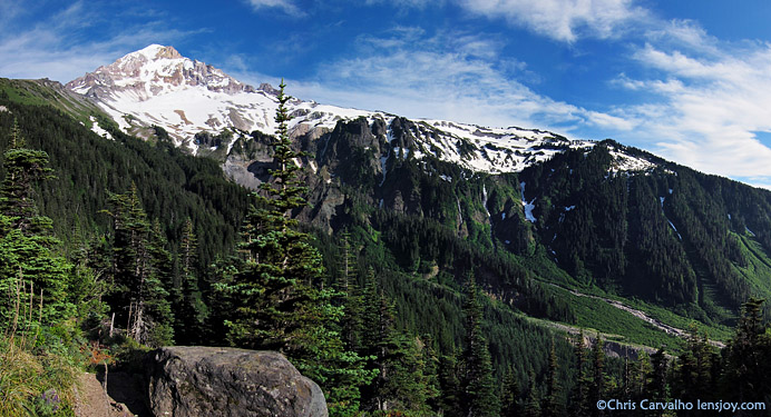
Oregon's Mt. Hood and the Muddy Fork of the Sandy River,
McNeil Point Trail. How much is this view worth to you?
As soon as I returned from the trip, I joined the Sierra Club and The Nature Conservancy. Since that time, I've donated a lot of money to various organizations. Some have done well with it, others not so well. I plan to make some major changes in my giving soon and I'll write about that. I will say for now that The Nature Conservancy is still doing great work and deserves your support.
In the 20-plus years since that memorable evening, I've been drawn back to the notion that the lack of attention to preserving the natural world comes down to the simple fact that people who enjoy Nature don't put their money or time where it can make a difference. Every night, thousands of hikers post photographs online in web forums hoping to get a "frequent poster" star rating. If they took that time and wrote letters to elected officials instead, something truly worthwhile might result.
We all need to be "In Business For The Wilderness." Big Oil, Big Energy, Big Mining, and Big Housing all know the value of developing wild lands to their future profits. The conservation community needs to understand the value those lands have to their own future and the planet's well being, and start paying that value to influence those in power who make the decisions.
The Windmills Are Coming
Entry 1: June 6, 2010
The Columbia Gorge faces many development threats. This one wasn't even on the radar screen ten years ago. But in the past few years as I hike and even drive the roads something is slowly creeping into my conscious perception, bit by bit. As I drive east starting near Hood River, in the far distance there's now a white jagged appearance to the horizon. At the top of the McCall Point trail on any clear day the wind turbines are visible. Eastward from there, on just about any high peak one can see a forest of white pinwheels is growing.
The shot above was taken from the top of Stacker Butte, also called Columbia Hills State Park. It is just a small piece of a much larger panorama. I am providing the full image so you can appreciate the impact. Remember that it is copyrighted, so any publication or non-educational use must be licensed by contacting me. To download it, click here. This is a 1.7 MB file, so it may take some time to load. The view is toward the east with the farms of the Klickitat River valley in the foreground.
Once you open it, you will see thousands of turbines. My camera isn't good enough to show the most distant ones, but if you look closely they extend almost to the left (north) and right (south) edges of the view. They are getting closer to the edge of the Scenic Area boundary. In fact, a project called Whistling Ridge is in the approval process right now just north of Hood River on the Washington side of the Gorge, and it will be on the edge of the boundary and visible from Nestor Peak and Mitchell Point. It is a galling insult to the spirit of the Scenic Area Act to place a wind energy project a stone's throw from the regional boundary and call it compliant with the Act.
Now I'm a big fan of renewable energy, but something about this march of the turbines reminds me of what happened when The Dalles Dam was built and drowned Celilo Falls. We didn't appreciate what we lost at the time, and now it's unlikely we'll ever get the falls or the salmon back for decades to come, maybe never. Early research is documenting how these turbines kill birds and bats (1), and it's obvious what they do to the view. They also create noise pollution that aggravates nearby residents as well as jams the communication calls birds and other creatures use for breeding, finding food, and predator avoidance. We've got to stop building them so close to the Scenic Area until we know more about their long-term effects, and also come to an understanding about how much visual impact we should tolerate. In the meantime, we can look at something proven to meet our growing demand for energy that doesn't have any negative impacts. It's called conservation.
Few of us realize the rapid pace of this change. Soon it won't be possible to go on a hike to a viewpoint anywhere in the eastern end of the Gorge and see a pristine east horizon. Most of it is already gone. The view of the horizon was something I took for granted. Today I realized it's been taken from us and might never come back.
To comment on the Whistling Ridge wind energy project, go to http://www.efsec.wa.gov/whistling%20ridge.shtml
The project contact person is currently Stephen Posner, his information is
located at the very bottom of the page.
Your comments will likely carry more weight if submitted to the Bonneville Power Administration (BPA). The Washington EFSEC typically defers to the wishes of rural counties, which are hungry for the tax dollars these projects provide. The counties have a history of ignoring the environmental impact when corporations wave money at their officials.
Comments to the BPA can be submitted at http://www.bpa.gov/applications/publiccomments/OpenCommentListing.aspx
Scroll the page down to find the section on the Whistling Ridge Energy Project
and click the "Make Comment" button.
